|
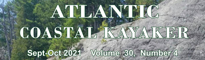
The replica Blackistone Light on St. Clements Island, l. to r. the author, Greg Welker, Gary Trotter, John Mavri.
Kayak Touring in Chesapeake Bay
By Ralph Heimlich
Have you ever wondered about kayaking and camping out of your boat? The Chesapeake Bay area has many places where you can do an overnight on the water at a paddle-in campsite. The Chesapeake Bay Water Access Map on the Chesapeake Paddlers Association (CPA) website lists a total of 64 paddle-in sites around the greater Bay area. However, if you want to take a multi-day trip where you paddle from site to site along a route (known as kayak touring), your options are more limited. This article focuses on one of my recent trips to illustrate some challenges, and on two well-developed water trails that follow the Patuxent River in Maryland and the mid-Potomac River forming the border between Maryland and Virginia.
In July 2021, three other CPA paddlers and I did a two-night kayak tour of two new paddle-in campsites at Newtown Neck State Park near Leonardtown, Maryland. I had a particular interest in these sites because for two years I served on the MD-DNR Planning Committee for this new state park and advocated strongly for including paddle-in camping to facilitate kayak touring. I was successful in having the two sites included in the plan, and park staff quickly marshaled resources and got the two sites built.
One problem with paddle-in camping is illustrated by what happened the first day of our planned trip. Kayak campers need some safe place to leave their vehicles while out enjoying the water. The logical place to park and launch would be Newtown Neck SP itself, but they unaccountably have a policy of no overnight parking in the park. I'd planned to launch from the beach at Colton Point, Maryland, which we'd often done in the past for trips. I'd contacted the Colton Point Museum for permission to park our cars in their overflow lot, but when we arrived at the beach, adjacent property owners had posted new no trespassing signs on the beach side of the road, claiming ownership of what had previously been perceived as a publicly-accessible beach. Plan B was to find a nearby marina, and for $5 a car, we parked and launched at their ramp.
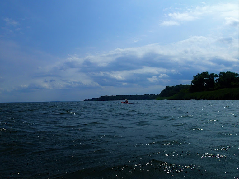
After we got on the water, we paddled across the Dukehart Channel to St. Clements Island, the site where the Calvert colony first landed in Maryland in 1634. In addition to a giant white cross commemorating the landing erected in 1934, the island now boasts a replica of the original Blackistone Lighthouse, which was open to tour. The view from the fourth floor light cupola was spectacular!
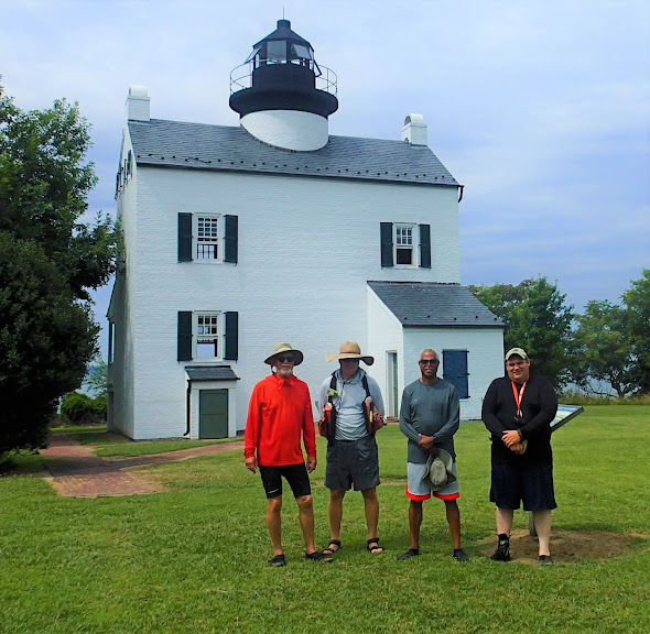
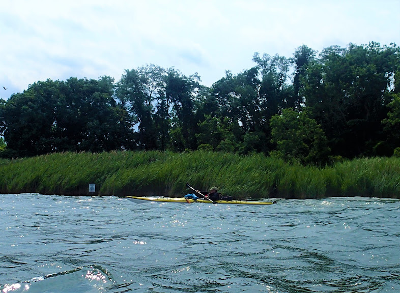
After we relaunched we crossed the Heron Island bar, marking where yet another of the Chesapeake Bay's islands has disappeared, and entered Breton Bay. Our campsite was on the Newtown Neck peninsula in the park, but we paddled up the eastern shore, exploring as far as Abell's Wharf. We then paddled down the western side of the Bay, stopping to check out the park's kayak launch at St. Nicholas Creek, then down to the camp site itself.
The paddle-in campsites at Newtown Neck are primitive. The one on Breton Bay consists of a nice sandy beach behind stone quoins, a sandy area to haul the kayaks out and hang out on, and a small (15 x 15 foot) sand pad enclosed by landscape timbers nestled into the dune grass beyond the sand. There is a picnic table and a metal food pole, but no open fires are allowed and waste facilities are strictly Leave No Trace. It was a tight squeeze shoehorning our four tents onto the small pad, especially because John had brought his four-man tent along. Fortunately, Saturday was overcast and cool (for July). There were no mosquitoes or other bugs, and steady breeze, wind-driven waves pounding on the shore, and rising full moon singed a burnt orange by the western wildfire smoke in the atmosphere lent an autumnal feel to the air.
After a quick breakfast, we broke camp early to get on the water in the cool of the morning. We paddled around the entire peninsula, across the beautiful beaches that front on the Potomac shore, and up into St. Clements Bay. Again, we didn't want to arrive at camp too soon, so paddled the eastern and northern shores of St. Clements Bay as far as the head of the Bay, past an eclectic collection of old farm houses and new waterfront mansions. We stopped for lunch at a wooded sand spit on Shipping Point, then paddled on up Canoe Neck Creek before turning to cross St. Clements Bay to our camp site.
Sunday afternoon was quite different than Saturday. We were on the western side of the peninsula, so the sun shone directly down on the campsite with no shade. There was no breeze and it was much more like a typical late July day on the Chesapeake: Hazy, Hot and Humid! We climbed the small bank and hung out in the shade of a fringe of trees separating the agricultural fields from the beach. Four big guys in tiny little camping chairs dozing bolt upright in the heat!
Once the sun was mostly down, the temperature moderated and a slight breeze off the water developed, making it tolerable to cook dinner around the picnic table. Without much breeze, the mosquitoes quickly arrived and we hit the sack pretty early in the evening.
After an early breakfast and shoehorning all the dewy gear back in the boats, we were back on the water, headed for our takeout.
To work best, water trails for kayak touring require a series of paddle-in campsites that are approximately one day's paddling (about 10-12 miles) apart. Ideally, they would all be managed by the same authority and have put-ins with secure overnight parking for your vehicle. We are not quite there in all cases, but the "bones" of well-organized kayak touring water trails are in place on the Patuxent and Potomac Rivers. Most sites are managed by the county in which they are located, and state parks generally handle their own paddle-in campsite reservations. They are generally not listed on state online camping reservation sites. Adding to the confusion is that many staff at these parks are not aware that they even have paddle-in sites to reserve, stemming from their infrequent use. Be prepared to insist and speak to a supervisor if your initial contact is negative.
Kayak Touring on the Patuxent Water Trail — There are currently 11 paddle-in campsites that make up the Patuxent Water Trail. They are documented in what is now the fourth edition of the Patuxent River Water Trail Guide and GPS-Ready Map, created by CPA member Dave Linthicum and available through the Patuxent Riverkeeper and at the visitor centers of the Jug Bay Wetlands Sanctuary (AA county) and Jug Bay Natural Area (PG county). A good launch for the upper part of the water trail is the Queen Anne Canoe Launch (at mile 53, measured upstream from the Drum Point light). You can obtain the gate code and parking passes for overnight parking here (and at Selby Landing) from MNCCPC at Jug Bay Natural Area.
When considering a kayak tour of the Patuxent, you need to think about arranging a shuttle since the distances involved can be substantial (53 river miles from Solomons Island to Queen Anne Canoe Launch). Many of the camp sites are relatively close to each other, but on opposite sides of the river, so a large loop route may be advisable (e.g., Selby Landing to White Oak Landing, then to Spice Creek, and back up to Emory Landing, then return to Selby Landing). Tides are another consideration, since this entire stretch of the river is tidal. The tidal difference on the river is not great (about 1-2 feet), but it is a lot easier paddling with the tide than against it. Consider setting your departure times to coincide with the tide moving in your direction (up or down stream). River current is negligible, except in the top five miles or so (river miles 48-53), so don't count on much help from the current.
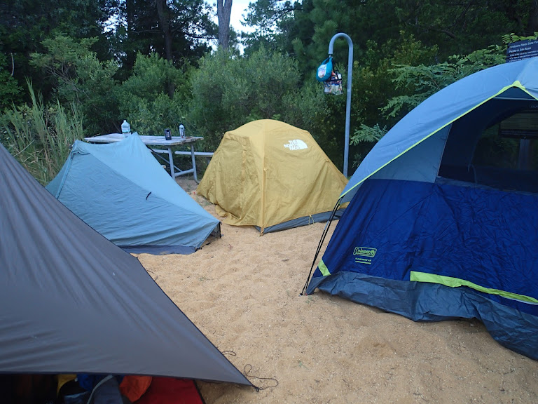
Shoehorning four tents on a pad wasn't easy.
In descending order down the river, the campsites are:
Mile 51: Stockett's Run campsite (AA County)
Mile 44a: Iron Pot Landing (MNCPPC, up Western Branch)
Mile 41a: Emory Landing (AA County)
Mile 41: Selby Canoe Camp (MNCPPC)
Mile 40: Selby Landing (MNCPPC)
Mile 40a: White Oak Landing (MNCPPC, up Mattaponi Creek)
Mile 35a: Spice Creek (MNCPPC, at the mouth of Spice Creek)
Mile 30: Milltown Landing (MNCPPC)
Mile 23: Maxwell Hall (Charles County, up Swanson Creek)
Mile 20: Indian Creek (Myrtle Grove WMA, up Indian Creek)
Mile 9: Greenwell State Park (DNR, Point Lookout SP, up Hog Neck Creek)
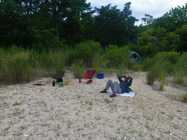
Hanging out on our "beach."
Contact information (note that often staff are not familiar with paddle-in campsites, you may have to explain in some detail before you find someone knowledgeable to deal with):
• Maryland National Park and Planning Commission (MNCPPC) is located at the Jug Bay Natural Area HQ at Jackson Landing — 16000 Croom Airport Road,Upper Marlboro, MD 20772, (301) 627-6074.
• Anne Arundel County Parks and Recreation Department (AA County). 1 Harry S Truman Parkway Annapolis, MD 21401, (410) 222-7313. Paddle-in Camping page.
• Charles County Parks and Recreation Department (Charles County). 8190 Port Tobacco Rd, Port Tobacco, MD 20677, (301) 932-3470.
• Myrtle Grove Wildlife Management Area (WMA). 5625 Myrtle Grove Rd. LaPlata, MD 20646 (301)743-5161.
• Point Lookout SP (DNR). 11175 Point Lookout Road, Scotland, MD 20687, (301) 872-5688.

The easy landing beach.
Kayak Touring on the Tidal Potomac River — The situation on the Potomac River is less organized than on the Patuxent, partly because the river is the boundary between Maryland and Virginia, and partly because development of campsites on the river is more recent. There is no official river distance signage on the Potomac, but I have created one using the center line mileage that approximates distance from the mouth of the river. There are seven paddle-in campsites on the Virginia side of the river, and seven on the Maryland side.

Big, hairy, and scary, but it's still just a moth.
Mile 113: Pohick Bay Regional Park, Va. (Camping is about a half-mile up from the kayak landing on Gunston Cove via a paved road.)
Mile 102: Leesylvania State Park, Va. (The paddle-in campsite shares facilities with group campsite at Bushey Point landing on Powells Creek.)
Mile 101: Smallwood State Park, Md. (Campsites are across a wooden foot bridge from Sweden Point Marina landing on Mattawoman Creek.)
Mile 99: Chicamuxen WMA, Md.(Two campsites located up Chicamuxen Creek.)
Mile 89: Widewater State Park, Va. (Paddle-in campsites share facilities with picnic area.)
Mile 81: Lions Club Camp Merrick, Md. (In the past, paddlers have pre-arranged to camp here.)
Mile 75: Friendship Landing Park, Md. (There is a single tent platform on a steep bank up a small creek off Nanjemoy Creek northeast of Friendship Landing, first come-first served, no reservations.)
Mile 77: Caledon State Park, Va. (Six camp site areas serviced by a porta-potty, can be reserved or use the pay station.)
Mile 69: Chapel Point State Park, Md. (A large open field with picnic table and fire ring a short ways up the Port Tobacco River, serviced by Charles County Parks department.)
Mile 56: Colonial Beach, Va. (It may be possible to pre-arrange hotel/motel accommodations here for overnight stays.)
Mile 49: Westmoreland State Park, Va. (A paddle-in campsite is located at the down-river end of the beach. There are also regular campsites about a mile up a steep paved road.)
Mile 43: Newtown Neck State Park, Md. (There are two paddle-in campsites here, one on Breton Bay to the east and one on Saint Clements Bay on the west of the peninsula.)
Mile 33: Coles Point Marina and Resort, Va. (There is RV camping at this marina and they may accommodate paddle-in tent campers.)
Mile 23: Chancellor's Point Campground, Md. (This is about five miles up the St. Marys River and consists of six tent pad sites.)
Mile 14: Point Lookout State Park, Md. (There are 15 designated campsites which can be reserved on the Green and Hoffman Point waterside loops.)
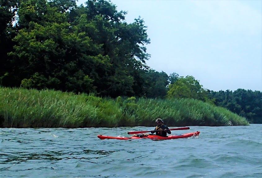
Running down Breton Bay to the campsite.
Contact information (note that often staff are not familiar with paddle-in campsites, you may have to explain in some detail before you find someone knowledgeable to deal with):
• Pohick Bay Regional Park, Va. 6501 Pohick Bay Dr, Lorton, VA 22079. (703) 339-6104.
• Leesylvania State Park, Va. Reservations must be made through the park. 2001 Daniel K. Ludwig Dr., Woodbridge, VA 22191; Phone: (703)730-8205. Leesylvania@dcr.virginia.gov
• Smallwood State Park, Md. Camping reservations through the Maryland State Park site. 2750 Sweden Point Road, Marbury MD 20658. (301)743-7613. smallwood.statepark@maryland.gov
• Chicamuxen WMA, Md. These sites are managed by the Myrtle Grove Work Center, 5625 Myrtle Grove Rd. LaPlata, MD 20646. (301) 743-5161.
• Widewater State Park, Va. Reservations must be made through the park. 101 Widewater State Park Road, Stafford, VA 22554. (540) 288-1400. widewater@dcr.virginia.gov.
• Lions Club Camp Merrick, Md. PO Box 56, Nanjemoy, MD 20662. (301)-870-5858. info@LionsCampMerrick.org.
• Caledon State Park, Va. Unlike the other Virginia state parks, these sites are in the state's online reservation system using ReserveAmerica. 11617 Caledon Rd., King George, VA 22485. (540) 663-3861. Caledon@dcr.virginia.gov.
• Chapel Point State Park. This is now managed by Charles County Recreation Department . (888) 432-2267 in Charles County. Other aspects contact Smallwood State Park, 2750 Sweden Point Road, Marbury, MD 20658. (301) 743-7613.
• Westmoreland State Park, Va. This site needs to be reserved directly with the park. 145 Cliff Road, Montross, VA 22520. (804) 493-8821. westmoreland@dcr.virginia.gov.
• Newtown Neck State Park, Md. This site is managed by Point Lookout SP (301)872-5688. pointlookout.statepark@maryland.gov.
• Coles Point Marina and RV Resort, Va. 190 Plantation Drive, Hague, VA 22469. (804) 472-4011. info@colespointmarina.com.
• Chancellor's Point Campground is part of Historic St. Mary's City 18751 Hogaboom Lane, Lexington Park, MD 20653. Details here. (240) 895-4980. groups@digshistory.org.
• Point Lookout State Park, Md. only Loop B Green's has water access. Reservations through the Maryland State Park site. (301)872-5688. pointlookout.statepark@maryland.gov
Training for kayak camping is not necessary, but remember that you are limited more by space (in your boat and through your hatches) than by weight. Even the smallest kayaks can carry much more weight than the typical back packer can handle. Compared to back packing, kayak camping can be considered "glamping!" Pack everything that can be damaged by water in dry bags, even though it will be in the waterproof compartments (they aren't). Pack heavy items (cook ware, food) closest to the cockpit and low in the boat, and lighter items (clothes, sleeping pads) in the ends of the kayak. Water can be carried in flat skins or bags and packed in the cockpit under your legs or in front of the footpegs. Smaller collapsible containers like Platypus or Camelback bottles can be squeezed into spaces in the hatches. It is a good idea to limit deck-loaded items because they negatively affect your kayak's stability and increase your windage. As far as clothes, consider limiting yourself to one set of paddling clothes and one set of "camp" clothes, rinsing and drying paddling clothes as needed. While kayak camping isn't limited to summer, that is probably the best season to start because you can get by with fewer clothes and a less bulky sleeping bag.
The best way to learn about kayak camping is to get out there and try it! The best way to have a place to kayak camp is to become active in your local area and advocate for real water trails and paddle-in campsites.

Map by David Eden.
|